Record SL-671499 · Wikidata Q944336
Independence Rock
No list classifications
Elevation
1,833
m
6,014 ft
Prominence
—
Isolation
—
Coordinates
42.4941° N,
107.1326° W
Grid ref
—
Description
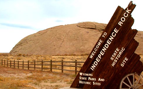
WikipediaIndependence Rock is a large granite rock, approximately 130 feet (40 m) high, 1,900 feet (580 m) long, and 850 feet (260 m) wide, which is in southwestern Natrona County, Wyoming, United States, along Wyoming Highway 220. During the middle of the 19th century, it formed a prominent and well-known landmark on the Oregon, Mormon, and California emigrant trails. Many of these emigrants carved their names on it, and it was described by early missionary and explorer Father Pierre-Jean De Smet in 1840 as the Register of the Desert. The site was designated a National Historic Landmark on January 20, 1961 and is now part of Independence Rock State Historic Site, owned and operated by the state of Wyoming.
Best months
Hiking score 0–100 · 10-yr climate averagesRows beneath each bar: mean temperature, monthly precipitation. Highest-scoring month in red.
Neighbouring summits
| Name | Elevation | Bearing | Distance |
|---|---|---|---|
| Fort Ridge | 2,186 m | S 167° | 4.7 km |
Climbing routes
nearest first| Route | Area | Grade | From summit |
|---|---|---|---|
| Handcart Misery | Devils Gate | 7a | 8.3 km |