Skip to content
SUMMITLOG
Start a log
North America / United States / Colorado / Vail Pass Summit
Record SL-637180 · Wikidata Q124381

Vail Pass Summit

No list classifications
Elevation
3,250 m
10,663 ft
Prominence
Isolation
Coordinates
39.5413° N, 106.2161° W
Grid ref
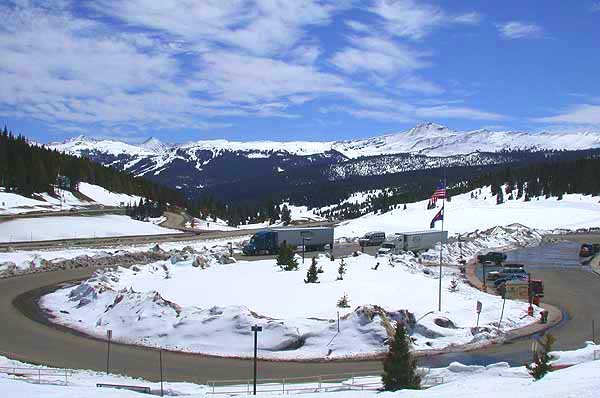
Vail Pass Summit
Vail Pass SummitWikimedia Commons

Description

Wikipedia

Vail Pass is a 10,662-foot-high (3,250 m) mountain pass in the western United States, located in the Rocky Mountains of central Colorado. The pass was named for Charles Vail, a highway engineer and director of the state highway department from 1930 to 1945. Vail Pass lies on the boundary between Eagle and Summit counties, between Vail on the west and Copper Mountain on the east. It provides the route of Interstate 70 (and earlier U.S. Highway 6) between the upper basins of the Eagle River and the Blue River, both tributaries of the Colorado River. Black Gore Creek, a tributary of Gore Creek, in the watershed of the Eagle, descends from the north side of the pass towards the town of Vail. West Tenmile Creek, in the watershed of the Blue, descends from the south side. The pass is significantly steep on either side (7% max.), and two runaway truck ramps are available on the west bound side for trucks. The pass has been featured on dangerousroads.org as one of the most difficult sections of road to navigate in Colorado: "Vail Pass, a difficult road in Colorado", due to its extreme grade, high elevation and frequent weather related hazardous driving conditions. The pass was not a traditional historical route of the Rockies. Prior to 1940, the most common route westward was over nearby Shrine Pass, just to the south, which leads to the town of Red Cliff in the upper Eagle Valley. In 1940, the construction of U.S. 6 bypassed Shrine Pass in favor of the current route to the valley of Gore Creek.
Best months

Rows beneath each bar: mean temperature, monthly precipitation. Highest-scoring month in red.

Neighbouring summits

Name Elevation Bearing Distance
Uneva Peak 3,819 m NE 44° 2.5 km
Sneva Peak 3,736 m E 83° 3.3 km
Shrine Mountain 3,621 m W 260° 3.8 km

Climbing routes

nearest first
Route Area Grade From summit
Copper Mt. Beginner Wheeler Lakes 4b 4.7 km
Tres Amigos Tenmile Canyon aka Officer's Gulch 5a 6.4 km
Upper Tiers Tenmile Canyon aka Officer's Gulch 4c 6.4 km
Lucky Ledges Officer's Gulch West 5b 6.6 km
Simul I Officer's Gulch West 5c 6.6 km
Outgoing Officer's Gulch West 6a 6.6 km
Patience Officer's Gulch West 5b 6.6 km
Incoming Officer's Gulch West 6a 6.6 km
Aspirations Officer's Gulch West 6c+ 6.6 km
Dirty Downs Officer's Gulch West 5c 6.6 km
Logan's Run Officer's Gulch West 5b 6.6 km
Sinus Infection Officer's Gulch West 5b 6.6 km
House of Cards Officer's Gulch West 5c 6.6 km
Notches Officer's Gulch West 5a 6.6 km
Trinity Officer's Gulch West 6a+ 6.6 km
Temptation Officer's Gulch West 6a 6.6 km
Corner Route Officer's Gulch West 6a 6.6 km
Twisted Ankle Officer's Gulch West 4b 6.6 km
Face-it Officer's Gulch West 5b 6.6 km
Rookies' Demise Officer's Gulch West 5b 6.6 km
Short-N-Sweet Officer's Gulch West 5b 6.6 km
The Plug Diamond Wall, The 6b 6.7 km
Cosmic Charlie Diamond Wall, The 6c 6.7 km
Lucy Diamond Wall, The 6c 6.7 km